Pete Nelson is a teacher at Whatcom Middle School and a freelance writer. His email address: pjnelson1965@yahoo.com.
A disagreement about zoning determinations that began in June 2000 between Whatcom County and a store at the south end of Lake Whatcom continues nearly two years and several appeals later. Neighbors and patrons of the Park Store (also called Scooter Stuff) have written more than 20 letters to Whatcom County and over 900 people have signed a petition in support of the store.
Bellingham Herald reporters have written three articles about the conflict. Whatcom Watch included a question about the store to County Council candidates last October. The Whatcom County Council voted on the issue in February 2001 and it’s now before the Whatcom County Superior Court.
No longer a simple dispute between two parties, it’s become a story about historic preservation, the watershed, the power of perception, and distrust.
Whatcom County Councilmember Barbara Brenner, a vocal advocate for the store, questions the county’s priorities. At a time when county revenues are declining, the administration prepares to defend the case in court.
“The bureaucrats don’t pay for it. The public pays for it,” Brenner said.1
The Park Store has stood at the intersection of Park Road, Blue Canyon Road and South Bay Drive since 1929. For fifty years the building, on the Whatcom County Historical Society register since 1979, was the general store and meeting place for the residents of Park, a mining and logging community at the south end of Lake Whatcom.
By 1990, however, the population of Park, once 2,500 strong, contained 20 households within one square mile of the store. The historic building no longer housed a store or residence; it had become an abandoned hull in which young people partied and hung out.
While visiting family in 1990, Bob Van Houten and Shelly Harper fell in love with the south end of Lake Whatcom and saw the potential for a business and residence at the for-sale Park Store building.
“Something grabbed me when I drove by [the Park Store],” Van Houten said.
“My mother thought I was absolutely crazy to even think about it.” 2
Van Houten and Harper, computer and electrical engineers working for the defense industry near the nation’s capital, had tired of the travel and long hours their jobs demanded. Van Houten, born and raised in Washington State, wanted to move closer to his parents and siblings.
“The whole family —two brothers, a sister and their families— all live within 50 miles of us,” Van Houten said.3
The couple realized that restoring the dilapidated building and opening a business there would require a rezone from rural to commercial. They met with Dan Taylor, then Whatcom County Land Use Division Manager, to discuss the possibility of rezoning the property on which the Park Store stood. The county, at first reluctant, was concerned that the couple would level the historic building and build a 7-11.
The two parties signed an agreement, which specified that the new owners would renovate the building according to federal restoration guidelines and operate a business out of the existing structure. With this agreement signed and environmental studies completed by the applicants, the Planning and Development Services staff recommended the Whatcom County Council approve the rezone from rural two-acres to neighborhood commercial.
Once the council approved the rezone, Van Houten and Harper purchased the property and went to work. They first secured the building by lifting it two and three feet up on jacks. They stabilized the foundation and then brought the building back down.
“That wasn’t done by Joe Schmo moving company,” Van Houten explained. “That was done by us, my dad; it was a family project.” 4
At the time of the purchase and during the first years of renovation, Van Houten and Harper planned to open a restaurant that would cater to the neighborhood, to road travelers, and to visitors to the adjacent 98-acre park that the county planned to establish. While waiting for the creation of the park, the couple, working various engineering, general contracting and retail jobs, invested their savings—nearly $ 200,000—into the renovation.
The proposed 98-acre park was never created. Without the park as a draw and the neighborhood population at less than 100 people, Van Houten and Harper calculated that the chances of making a restaurant profitable were highly unlikely.
They searched for a new business idea. Turned on to motorcycling by Van Houten, Harper had quit engineering and worked for four years at a local Harley Davidson store. Her experience at the motorcycle store and the traffic passing by their home ignited an idea. The couple decided to create two businesses within the Park Store. They would sell groceries and motorcycle parts and accessories.
“We were sitting out in the front stoop drinking coffee right next to the road one evening talking about we have to do,” Van Houten explained, “As we sat out here in this beautiful area, it became clear to us all the people driving by. We thought, ‘Let’s try to set up a business selling motorcycle parts and accessories.’” 5
The Park Store added a new name: Scooter Stuff. Along with milk, eggs, and bread, the owners began selling T-shirts, jackets and later added other clothes and parts. They offered free coffee and a table for conversation. Upon request, Van Houten and Harper bolted chrome onto motorcycles and changed tires for their customers.
Motorcycle repairs that involved the release of fluids were available to customers but, due to watershed concerns, were not done at the Park Store site.6
A year and a half after Scooter Stuff opened, Steve Mann, a county zoning compliance officer, responding to a citizen complaint, visited the store unannounced. In the complaint, a county resident expressed concern that the originally planned restaurant had never opened and that, instead, the owners were selling motorcycle parts. It was noted that a creek runs under the building into Lake Whatcom and alleged that motorcycles were being repaired.7
“A man walks in one day and introduces himself as a compliance officer and says he’s here to check out our business,” Van Houten said. “Basically he left saying, ‘I don’t see any problem. This is great.’” 8
Three weeks later on May 22, 2000, Van Houten and Harper received a letter from Mann. He wrote that, although at the time of his visit he did not feel that the store’s business was in conflict with the zoning, after further research and consultation with administrators, it had been determined that the store was in violation of the zoning.
The intent of the neighborhood commercial zone was to provide convenience goods and services to the neighborhood. A motorcycle parts and accessories store would attract people outside the neighborhood and “would most likely cause an increase in out-of-area traffic,” he concluded.9
He informed the owners that they must stop selling motorcycle parts and accessories within 30 days.
“If you fail to meet this deadline, a $250.00 Notice of Infraction will be issued. A Notice of Infraction may be issued for each day of noncompliance,” Mann wrote.10
Shortly after receiving the letter, Van Houten and Harper met with county officials; the two parties were unable to resolve the issue. The owners then hired lawyer Philip Buri and appealed the determination to Whatcom County Hearing Examiner Michael Bobbink. In December of 2000, Bobbink heard arguments and testimony from both sides and overturned the county’s determination.
Bobbink ruled that the county’s interpretation of the zoning was overly strict. He emphasized that the impact of the Park Store on the neighborhood is consistent with permitted uses of the neighborhood commercial elsewhere.
“The motorcycle accessories portion of the business was designed to serve travelers who already use the road,” Bobbink wrote.11
After Bobbink refused to reconsider the decision, the county appealed the case to the Whatcom County Council. The county’s prosecuting attorney Karen Frakes and the Park Store attorney Buri submitted legal briefs to the council.
The two parties disagree over what criteria to use when determining which specific business activities are allowed under the neighborhood commercial zone.
The central issue, according to the county, was whether the sale of motorcycle parts and accessories is a permitted use in a neighborhood commercial zone. The county argued that businesses in the zone should provide neighborhoods with convenience goods, like food, drugs, hardware, and stationery.
“A motorcycle parts and accessories shop is a specialty retail store that would appeal to a very select segment of population and would attract customers from outside of neighborhood for its survival,” Frakes wrote.12
The Park Store attorney argued that impacts of the store on the neighborhood, not the goods and services sold at a store, should be the focus of the county’s determination
“The key to assessing the use of a neighborhood store is whether the store creates negative impacts on the surrounding community. Here the Park Store has created none,” Buri wrote.13
Buri also argued that more objective criteria — minimum lot size, maximum building size, building set backs, height limitations, lot coverage, open space buffer areas, sign regulations — should be used to determine neighborhood commercial zoning compliance.
“Planning and Development Services does not contend that the Park Store has violated any of these specific requirements on building size and lot configuration,” the attorney wrote.14
Hardware store is one permitted use under the neighborhood commercial zoning code.
“How could mechanical parts for motorcycles not fall within the broader definition of hardware?” Buri asked the council.15
In February of last year, the council overturned the hearing examiner’s decision with a four to one vote. Voting to overturn the decision were councilmembers Connie Hoag, Robert Imhof, Ward Nelson, and Dan McShane. Sam Crawford voted in favor of the hearing examiner’s decision. Barbara Brenner recused herself and Marlene Dawson was not present. The result of the decision: the Park Store must stop selling motorcycle parts and accessories or face a $250.00 fine for each day of noncompliance.
Van Houten and Harper filed an appeal at the Whatcom County Superior Court. During this appeal — which has not yet been heard — the county agreed not to enforce the $250.00 per day fine until after the court ruling. In return, the store owners agreed any work on motorcycles at the store would not involve the release or storage of fluids in a manner that could harm the Lake Whatcom watershed.16
At the heart of this case beats one question: What does the county want?
Roland Middleton, Land Use Division Manager, explained that, when reading the hearing examiner’s decision, he became concerned the decision would create future problems.
“When I care is when someone’s land-use attorney uses this as a precedent. If the hearing examiner had made this case-specific, then fine. But he didn’t. He opened a huge can of worms,” Middleton said.17
County prosecuting attorney Frakes differed in her view of the hearing examiner’s decision. The hearing examiner tried to make the decision case-specific to the Park Store, she said, but his attempt to restrict the case would not prevent other land-use lawyers to argue that their case was also unique.18
“The hearing examiner’s decision leaves the administration in the position of having to allow any and all retail uses in a Neighborhood Commercial District as it would be impossible for staff to legitimately distinguish one such use from another,” Frakes argued.19
Zoning isn’t the county’s only concern. The Park Store is a couple hundred yards from Lake Whatcom, the drinking water source for 85,000 residents. The health of the lake and the effect of development around the lake have become critical topics of debate in the region.
The county is aware of the growing public concern for the lake’s health and is undoubtedly sensitive to any activity, or the public’s perception of any activity, that is potentially harmful to the Lake Whatcom watershed.
“Our major concern is harm to the water quality in Lake Whatcom,” Sylvia Goodwin, County Planning Manager, said.20
Van Houten and Harper have been frustrated in their efforts to address the county’s watershed concerns. They want to do what is necessary to protect the watershed, they said, but the county hasn’t been clear as to what they can and cannot sell or service.
“Their concerns change. First it was fluids. Then tires. Then it’s things that are considered repairs. The list kept expanding,” Van Houten said.21
Under the stay agreement with the county, Van Houten and Harper have agreed any work on motorcycles at the store would not involve the release or storage of fluids in a manner that could harm the Whatcom watershed.
“It’s not a question of environmentalists against evil polluters,” Brenner said. “That’s what bothers me the most. I get the sense that they care about the environment. I don’t think they are polluters in any way.”22
The Bellingham Herald reported in June 2001 that a land rezone could resolve the Park Store suit. County Council members plan to seek a rezone to allow the store to continue selling motorcycle parts.
“[Brenner] and councilmember Sam Crawford said they would ask the council to start the process to rezone the store to a designation, possibly tourist commercial, that would satisfy other council members and planning administrators,” The Bellingham Herald reported.23
At the time this issue went to press, however, neither Brenner nor Crawford had asked the council to start a rezone process.
Brenner is uncertain whether there are enough council members who would vote for a rezone resolution, which would direct the county staff to prepare a report and make a recommendation on the rezone issue. For the rezone process to be initiated, four of the seven council members would need to vote for it.
“I would (initiate the rezone process), if I thought I could,” Brenner said. “I saw which way they (the councilmembers) voted. They were listening to their attorney. I thought one council member was completely supportive of [the Park Store], and he turned around and voted against it.”24
Brenner views the efforts by the county as politically motivated rather than rooted in a concern for health or the environment. She distrusts the county administration, fearing that the county would use a rezone request against the Park Store during a trial. For a rezone to be approved by the council, it would need to have support from the Planning and Development Services office.
“The council and the administration should be working in unison. Otherwise we would be setting these people up,” Brenner said.25
According to Planning Manager Goodwin, the county has no plans to bring forward an application for a rezone. Planning and Development doesn’t bring forward an application process for private applicants.
“The only reason Planning and Development would bring forward an application would be for an issue that has some countywide benefit,” Goodwin said.26
Van Houten and Harper could apply for a rezone. The county would look at whether or not the rezone request would be consistent with the comprehensive plan, Goodwin explained.
“Tourist commercial is appropriate zoning for a comprehensive plan of crossroads commercial. We would probably recommend approval if it were tourist commercial,” Goodwin said.27
Goodwin said that if the owners applied for a rezone, they would have to pay $2,435 in fees. If the county initiates the rezone, the owners would have no fees.
Van Houten and Harper are open to applying for a rezone, but believe that the county should pay for the rezone, their attorney said. They argue that they had always planned to open a business—first a restaurant and now a motorcycle parts store—which attracts customers from outside the neighborhood. They were told that neighborhood commercial allows that.
“I don’t think that the Park Store should have to pay for a rezone when it is Planning and Development Services that has changed its definition of neighborhood commercial,” their attorney said.28
Is the continued restoration and maintenance of the Park Store, financed by Scooter Stuff revenue, of countywide benefit? Would it justify the county bringing forward a rezone application?
In the 1990 report that recommended a rezone for the Park Store, county staff wrote that providing an economic incentive for restoration of the historical Park Store was “in keeping with the County wide goal to preserve cultural resources.”29
“A contract rezone tying the right to rezone to the preservation of the building could protect the interests of the County (italics added),” the staff reported.30
The staff report suggests that continued restoration and maintenance of the Park Store is in the county’s interest.
At the taxpayers’ expense, the county has directed staff to investigate the Park Store, to argue before Hearing Examiner Michael Bobbink and the County Council, and to prepare for a civil suit. Yet the county has not directed nor, according to Goodwin, has any plans to direct any staff to bring forward a rezone application.
There may be an additional concern that has influenced the county’s actions. Rita Foley, a Blue Canyon resident for 32 years and one of two residents who testified before the hearing examiner, complained about increased motorcycle traffic.
“You can hear their motorcycles roaring down South Bay Drive from anywhere from seven in the morning until sometimes 12 at night,” she said.31
County staff members deny that the Park Store’s motorcycle-riding clientele has influenced their actions.
“We do not look at the prejudicial nature of the clients involved,” Middleton said.32
Political Climate Has Changed Since 1990
The political climate surrounding development in the Lake Whatcom watershed has dramatically changed since 1990, the year Van Houten and Harper purchased the historic Park Store building. Concern over toxins in the lake has affected government policy decisions. The Whatcom County Council recently enacted a subdivision moratorium in the watershed.
In light of heightened public concern for the lake’s health, it isn’t surprising that Whatcom County officials would investigate a motorcycle parts and accessories store operating in the watershed.
The Park Store owner’s willingness to take the necessary steps to prevent the release of toxic fluids into the lake raises a concern: Is the perception of a threat rather than a real threat to the Lake Whatcom watershed driving County Planning and County Council action?
The Park Store turns 73 this year. The original wooden walls, once covered by layers of wall paper and cardboard, have been exposed, sanded, and repainted. The wood foundation beams and the siding have been replaced. Native trees and ferns have been planted on the property. The renovated two-story rectangle building with the boomtown front facade and flat roof is the only building that remains from the early mining and lumber days in Park and neighboring Blue Canyon.
“What has made this business is the building, its history, its feeling,” Van Houten said. “To pick this business up and move it some place else would be just like anybody else’s some place else. This place is very special to us. Very special to our customers, extremely comfortable, and it should be special to the county because it’s their history.”33
Footnotes
1 Barbara Brenner, personal interview, 21 Jan. 2002.
2 Bob Van Houten, personal interview, 7 Feb. 2002.
3 Ibid.
4 Ibid.
5 Van Houten, personal interview, 18 Feb. 2002.
6 Van Houten, 7 Feb. 2002.
7 Citizen Inquiry Report case # EMF2000-00299, 10 May 2000.
8 Van Houten, 7 Feb. 2002.
9 Steve Mann, Land Use Specialist, Whatcom County Planning and Development Services, 22 May 2000.
10 Ibid.
11 Michael Bobbink, Whatcom County Hearing Examiner, Summary of Appeal and Decision APL2000-0012, 29 Nov. 2000.
12 Karen Frakes, Brief of Appellant, APL2000-0012, 29 Jan. 2001.
13 Philip Buri, Memorandum of Law in Support of the Park Store, APL2000-0012, 14 Feb. 2001.
14 Ibid.
15 Ibid.
16 Stipulation Regarding Stay Pending Appeal, Whatcom County Superior Court, No. 01 2 00666 1, 18 April 2001.
17 Rolland Middleton, personal interview, 25 Jan. 2002.
18 Karen Frakes, personal interview, 25 Jan. 2002.
19 Karen Frakes, Brief of Appellant, APL2000-0012, 29 Jan. 2001.
20 Sylvia Goodwin, personal interview, 28 Jan. 2002.
21 Bob Van Houten, personal interview, 24 Jan. 2002.
22 Barbara Brenner, personal interview, 21 Jan. 2002.
23 Aubrey Cohen, “Land rezone could resolve Park Store suit.” Bellingham Herald, 9 June 2001 page A3.
24 Brenner, 21 Jan. 2002.
25 Ibid.
26 Goodwin, 28 Jan. 2002.
27 Ibid.
28 Philip Buri, personal interview, Feb. 18, 2002.
29 Whatcom County Planning Department Staff Report, 14 Mar. 1990 File 06:90:CM.
30 Ibid.
31 Public Hearing, November 22, 2000.
32 Middleton, 25 Jan. 2002.
33 Van Houten, 7 Feb. 2002.
On February 26, 2002, the Whatcom County Council voted four to three against a resolution that would initiate a process to review rezoning the Park Store property from neighborhood commercial to tourist commercial. Councilmembers Dan McShane, Ward Nelson, Laurie Caskey-Schreiber and Sharon Roy voted against the resolution. Councilmembers Seth Fleetwood, Barbara Brenner, and Sam Crawford voted in favor.
The resolution was placed on the council’s agenda by the Whatcom County Prosecuting Attorney’s office.
Several people spoke in support of the Park Store during the open session, a twenty-minute period when audience members may address the council on any issue not scheduled for public hearing that evening. No one spoke against the rezone resolution during the open session.
In discussion prior to the vote, Councilmember Nelson questioned whether or not the council should be initiating rezones simply for the benefit of businesses. “While it (a rezone) may be well and good and I think it is for this business, it would also be well and good for many businesses that I would like to see that we initiate it for.”
In response, Councilmember Crawford said that the council rezones for benefit of the community and that the Park Store is a good example of that.
During the open session several supporters of the store referenced the Park Store’s historic value to the county. During the discussion no councilmember mentioned the Park Store building’s historic roots.
Whatcom County Planning and Division Manager Sylvia Goodwin. told the council at the meeting that the Park Store’s current use would be legal as tourist commercial and that tourist commercial is appropriate under a crossroads comprehensive plan designation.
The vote before the council on Tuesday night was not a ruling on a zoning designation for the Park Store. It was a vote about whether to begin a process to review the zoning designation. The process would involve a public hearing and a county staff report recommendation.
Near the end of the three-hour meeting, councilmember Fleetwood said that he would like to explain why he voted for initiating the review process for all resolutions on the agenda.. “The reason simply being for me personally is not because I necessarily support them all. I don’t want that impression to be left. I personally will benefit from the process, and being able to go out and look at the property and make phone calls and talk to people,” Fleetwood said.
Cover Story
Robert Schultz, a Sudden Valley resident, believes his last Whatcom Watch article helped preserve the Sudden Valley newspaper from board censorship. His email address: rschu@nas.com.
When the first plat of Sudden Valley was approved in 1969, its 1,200 acres became a threat to Lake Whatcom’s viabilily as a reservoir. The runoff pollution threat became reality with the construction of each new home that followed. Many trees have been cut over the years to make way for homes. There is the state Department of Natural Resources logging threat in the hills above Sudden Valley; other logging proposals have come from within the valley. If Yogi Berra came to Sudden Valley he would say it’s déjà vu all over again regarding logging proposals.
In 1987, the Sudden Valley Community Association (SVCA) commissioned an Olympia consultant to study what they called a selective “Tree Maintenance Program to increase long-term aesthetics and property values.” The proposed plan would have removed as many as 786 second-growth trees or as much as 400,000 board feet from a 40-acre section of Sudden Valley.
Many Canadian owners stopped paying taxes when their dollar plunged. Defaulting lots caused a glut in the valley’s property market. SVCA’s board claimed thinning out the forests would make property lots more marketable at higher prices because it would:
•Allow real estate agents to find lots more easily,
•Enable buyers to see entire lots and envision homes on them,
•Prevent root disease from spreading,
•Open up forests to sunlight, making land more attractive, and
•Nurture younger trees now being overshadowed.
The consultant also said the SVCA could expect $20,000 to $25,000 profit. It would be a perfect world of busy real estate agents, happy loggers, supposedly healthier forests and prospective buyers who want a beautiful wooded community—just so long as trees don’t get in the way.
SVCA called this a pilot project, with logging profits put in a “separate trust fund for other forest management projects in the valley.” The scheme was a precursor of thin(g)s to come. The tax defaulters were also not paying SVCA dues. Clearing trees could clear the way for new dues payers.
Concerned Valley residents greeted this proposal with anger and skepticism. They were not soothed by the pro-sunlight, anti-root disease sugar coating. They formed a “Save Our Trees Committee.” The committee’s expert advisors found the plan to remove almost half the area’s trees harmful to the forest and environment. (Some logging would be on slopes as high as 30 degrees.)
The potential damage to their properties, roads and watershed would actually lower property values, not raise them. One expert claimed SVCA’s profit would reach as high as $50,000, not the lower figure mentioned by SVCA’s consultant.
After many months of expert claim and counter-claim, the scheme died of malnutrition. Residents refused to feed loggers’ and realtors’ appetites; they would not sign licenses turning their property (trees) over to the SVCA.
We jump from 1987 to 2002. A recent issue of the Sudden Valley Views (a monthly newspaper) has a front page article about Azam Nader, the new owner of Sun-Mark Properties. This is legitimate news about her background and plans for her company. But, immediately under it on the same front page is an article by Ms. Nader, who is listed as a Views contributor. Here it is, slightly edited for brevity:
Can’t See the Beauty for the Trees
As the original real estate sales company in Sudden Valley, we at Sun-Mark Properties have seen the community and its property values decrease over the years. We feel that one of the factors that negatively impacts real estate values in this great community is the amount of trees and vegetation on some properties that result in problems for the potential home buyer.
Here are some of questions to ask:
•Do you have too many trees crowding your lot?
•Is your home “dark” even with the lights on?
•Are you having problems with not enough light because of excessive branches?
•Do you have too much moisture on your home due to direct contact with over-hanging branches?
•What does your roof look like? Is it clean or filled with branches and other debris?We would like to help. We are in the process of implementing a tree removal program for Sudden Valley home owners. We already have a tree removal company in place and hope to get the cooperation of the Sudden Valley Community Association and the Architectural Control Committee (ACC) to begin this program.
For those interested, call for a tree removal request form…Once the removal request has been received from the Architectural Control Committee, a crew will be dispatched to your property. At no cost to the home owner, the trees and other debris will be transported from the property. At that point, cut trees will be the property of Sun-Mark. A portion of the sales proceeds will be donated to the SVCA.
It is our intention to make this a free service to all Sudden Valley home owners....
There it is for all to see, familiar themes, then and now. “We’re doing this for your own good, we’re here to help you.” Homeowners’ reaction, as in 1987, is negative. Linda Marrom, who led the fight that stopped the state’s plan to clear-cut above Austin Creek, tells me she will fight this scheme as well. She speaks for a growing number of folks in the Valley in a letter to the Sudden Valley Views.
She writes that Sun-Mark’s statement about the amount of trees and vegetation negatively impacting real estate value “is a curious one.” She understands the need to cut hazardous trees or limbs and the removal of vegetation such as blackberries except near streams or wetlands.
“Azam mentioned working with big logging companies, not small tree and landscaping businesses. She said a portion of the timber money raised would go to Sudden Valley, but the majority would go to Sun-Mark and the logging company of their choice. I mean no disrespect to either, but when special interests are involved most decisions are made by dollar signs, not by environmental protection. It’s just a fact, not an insult.”
At a SVCA board meeting, another real estate agent said that sales were moving fast because her clients wanted to live among the trees. A homeowner said that if buyers don’t want trees they should not come to Sudden Valley. So, what happens next?
SVCA general manager Steve Grieser says Ms. Nader told him of her plans but he could make no promises. Architectural Control Committee chair, Dave Scott, told me that “I think she’s trying to be helpful to the valley, but she has to follow rules like anyone else.” When I told him Ms. Nader would wait until she had enough homeowners and prospective clients to all apply for permission to “thin,” he replied that pressure from either side would have no effect on his decisions.
Neither Grieser, Scott, or SVCA president Jon Wolfe would comment on the merits of her proposal. The Architectural Control Committee guidelines allow removal of trees, limbs and vegetation for reasons of safety, fire prevention and maintenance of property values where unchecked growth poses aesthetic concerns for neighbors, etc. The guidelines were not intended as a marketing tool for realtors.
The fate of this déjà vu logging proposal rests with the Architectural Control Committee and the board. The 1987 proposal was a creature of Sudden Valley management. The Sun-Mark proposal has no stated official support from SVCA. Dave Scott did tell me that money for SVCA will play no part in the Architectural Control Committee’s decisions. “But if she wants to give SVCA any money she’s free to do so.” He would be willing to meet with her as he would with anyone else and the guidelines will be followed.
Since any guidelines are subject to interpretation, the line between beneficial thinning and commercial logging could be too porous for comfort. There may be loopholes awaiting a clever legalist. Past events have made knowledgeable valley residents wary of such proposals.
Linda Marrom’s letter says she trusts SVCA to thoroughly scrutinize the Sun-Mark proposal and to adhere to Sudden Valley by-laws. She asks Valley residents to e-mail Steve Grieser at gm@ suddenvalley.com. Potential Sudden Valley home- buyers living in or out of our watershed might want to do the same.
Erika Schreder is employed by the Washington Toxics Coalition. She has an M.S. in resource ecology and a B.S. in molecular biology. She currently directs the Clean Water for Salmon Campaign, which aims to end pesticide uses that pollute water and threaten salmon.
Pesticide contamination of rivers and streams in the Northwest is extremely widespread and is causing harm to salmon. That’s the conclusion of Poisoned Waters, a new report published by the Washington Toxics Coalition and the Northwest Coalition for Alternatives to Pesticides.
The two groups completed a first-time analysis of government studies on pesticide contamination of salmon streams, and obtained definitive evidence that pesticides pollute salmon streams at levels that cause harm. The groups also analyzed the Environmental Protection Agency pesticide registration documents and found glaring deficiencies in the agency’s actions to protect salmon.
The report’s major findings are as follows:
•All major Northwest watersheds tested by the U.S. Geological Survey (USGS) are highly contaminated with pesticides. The USGS looked for pesticides in five different basins in the region. Each of those basins was contaminated with at least 35 pesticides.
•Sixteen pesticides pollute our waters at levels harmful to salmon. These pesticides have been found at levels that exceed standards set to protect aquatic life, indicating that they are likely to currently cause harm to salmon.
•EPA findings reveal that allowed uses of 36 pesticides are likely to harm salmon. The EPA has made determinations for three dozen pesticides that they are likely to pollute waters at levels that threaten endangered salmon, but has allowed their use despite the danger to salmon.
•EPA has failed to uphold the Endangered Species Act by not submitting detailed assessments of pesticide threats to salmon and restricting pesticide uses when threats are found. The Endangered Species Act requires EPA to submit assessments to the National Marine Fisheries Service, but EPA has failed completely to obey the Act despite the ten years since the first salmon listing.
The report also presents a case study of the pesticide contamination of Thornton Creek, which is the largest watershed inside Seattle city limits. The case study, based on a master’s thesis prepared by Elizabeth Loudon, details pesticide use within the watershed and the contamination of the stream that results.
Three pesticides were found in the stream at levels that harm aquatic life including salmon. Government agencies, individuals, and commercial pesticide applicators share the blame for the use of pesticides that harm salmon in Thornton Creek.
Washington State Department of Ecology has found harmful levels of pesticide pollution in Whatcom County waters as well.
The Department of Ecology sampled four sites in Lake Whatcom and Whatcom Creek in June and October 1998, for a total of eight samples for most pesticides. Fourteen pesticides and one breakdown product were detected out of 110 analyzed. At least five pesticides were detected in all but one sample.
Three pesticides were found at levels exceeding criteria set to protect aquatic life—chlorpyrifos, diazinon, and malathion. Pentachlorophenol was detected at one site at levels exceeding the human health criterion set under the National Toxics Rule.
Seven of the pesticides detected in the Whatcom Creek/Lake Whatcom Watershed have been detected in our region at levels at or above standards to protect aquatic life.
Although the testing completed in this watershed was relatively limited, with only two samples in each location for a total of just eight samples, it found significant contamination. The results clearly indicate that pesticide pollution is a serious problem for the health of Lake Whatcom and Whatcom Creek, for both the people and the salmon that use this water.
The pesticides present at levels exceeding standards to protect aquatic life were chlorpyrifos, diazinon, and malathion. All three of these insecticides have extensive home uses, as well as uses by institutions and in agriculture. A shelf survey of pesticides sold in Bellingham retail outlets found a number of products containing these ingredients.
More than 70 clean water, fishing, salmon recovery, faith-based, and civic groups agree that strong and swift action is necessary to get pesticides out of our waters and protect salmon. These organizations have joined the Clean Water for Salmon Network by endorsing the campaign Statement of Support, which calls for the following measures:
•Phase out the use of pesticides that are hazardous to salmon and their habitat.
•Adopt measures to keep pesticides out of water needed for salmon survival.
•Establish pesticide use reporting to track pesticide use to aid in salmon recovery.
•Promote and adopt salmon-friendly practices that reduce reliance on pesticides.
Poisoned Waters also presents specific recommendations for government agencies to protect salmon from pesticides. Among them:
1. EPA must comply with the Endangered Species Act by phasing out the use of pesticides that harm salmon and keeping all pesticides out of water. Until now, EPA has shirked its duty to make sure that the pesticides it allows for use do not contaminate water at levels that harm threatened and endangered salmon. EPA must act quickly to begin evaluating all the effects of pesticides on salmon and immediately restrict or eliminate pesticide uses where hazards are found.
2. The National Marine Fisheries Service must enforce the Endangered Species Act and ensure that pesticides are not used in ways that harm salmon. It is the responsibility of the National Marine Fisheries Service to ensure that EPA complies with its duties and to make sure that local governments also address the need to restrict and reduce pesticide use.
3. States should stop the use of pesticide products that harm salmon or their habitat by phasing out and restricting their use. Washington state has taken steps toward addressing the threats pesticides pose to salmon by establishing the state Pesticide/ESA Task Force. This task force is just beginning to assess the impacts of pesticides on salmon, and it is expected to recommend restrictions on pesticides to the Washington State Department of Agriculture. The task force and Department of Agriculture must ensure that salmon are protected by phasing out the use of pesticides that are found in our streams at harmful levels.
4. Local governments should make pesticide use reduction a core element of salmon recovery. Seattle and King County have led the way in Washington state by eliminating their use of the most hazardous pesticides and taking steps to reduce the rest. All cities, counties, ports, and school districts must pass ordinances or policies to eliminate their own use of pesticides that threaten salmon and human health, and replace pesticides with salmon-friendly alternatives.
5. States must establish pesticide use reporting systems to aid in salmon recovery. Government agencies and salmon recovery groups need information on what pesticides are used where and when in order to effectively target their pesticide reduction efforts.
The report also calls on farmers and individuals to replace pesticides with salmon-friendly alternatives, and calls on land grant universities to orient their research, extension, and education toward sustainable pest management practices rather than pesticides.
The City of Bellingham and Whatcom County should commit to ending their use of pesticides on public properties such as parks and roadsides. Bellingham and Whatcom County should also work with the Department of Natural Resources to reduce the use of pesticides on state-owned lands.
Residents in the Lake Whatcom and Whatcom Creek watersheds can help reduce pollution by taking the Watershed Pledge to reduce home use of pesticides and other toxics. The pledge is available from RE Sources for Sustainable Communities at (360) 733-8307.
The Clean Water for Salmon Campaign is working to press the government agencies named above to take strong action to protect salmon from pesticides. To join the Clean Water for Salmon Network and participate in the campaign, contact Erika Schreder or Kristina Logsdon at the Washington Toxics Coalition.
Copies of Poisoned Waters can be obtained by downloading them from the Washington Toxics Coalition web site at www.watoxics.org or by calling the coalition at (206) 632-1545.
Susan Kane-Ronning, Ph.D., is a resident of the Silver Beach neighborhood, and a licensed psychologist in private practice in Bellingham.
I have become preoccupied with polar bears. Obsessed, actually. It began when my brother sent me an article from Tidepool News (www.tidepool.org), by Donella Meadows. Meadows, a scientist who died last spring, details the decline of the polar bear due to global warming. Titled “Polar Bears and Three-Year-Olds on Thin Ice,” the article deftly describes the effects of industrial pollution and global warming in the Arctic.
According to Meadows, the Arctic is more sensitive to the effects of global warming—one degree warmer for the planet equals three degrees at the poles. Ice now covers 15 percent less of the Arctic Ocean than twenty years ago. Ten feet thick back in the 1950s, it is now less than six feet thick. At that rate, the Arctic may be ice-free all summer long within 50 years.
Two hundred species of tiny organisms, algae and zooplankton, which hang around ice floes and sink to the bottom when they die, nourish clams, which are eaten by walruses. Arctic cod eat the algae scraped off the ice, which are then eaten by seabirds, whales, and seals. The great white bear, the polar bear, is the head of the Arctic food chain, and hunts primarily seals.
By 1998, most of the plankton species were gone, and the ice was nearly gone. Plankton-dependent creatures were gone, as well as the ice-dependent seals, and the seal-dependent bears. Many had traveled farther north following the ice. Some creatures like the black guilllemot, a bird dependent on land for shelter and ice for food, can’t even bridge the gap between land and water, and the others remain precariously far from land.
So, for several months, I tried to force my mental picture of the polar bears out of my mind. Create a protective layer of denial while I drive my car and perpetuate my American lifestyle. Then several things happened. George Bush bowed out of the Kyoto Agreement on global warming, refusing to participate in reducing greenhouse emissions in the United States, the leading contributor.
While smaller countries diligently try to reduce their contributions, Ari Fleischer, Bush’s press secretary was quoted as saying that the Bush administration was not going to request American citizens to reduce their fuel consumption over the summer months—it was our American “right” to drive our automobiles.
Next, the Bush administration ardently strove to open the Arctic National Wildlife Refuge for drilling, even though scientists vehemently stated there would not be enough oil to warrant the drilling. Proponents used the California energy crisis and even the Afghanistan conflict after September 11 to justify the drilling.
My denial, although fairly ineffective in suppressing my anger and frustration, lost its grip one Sunday morning after the holidays. Waking before the rest of my household, I stumbled to the television and thought I would check out the weather. I found myself watching a show about polar bears in the Arctic.
Scientists were researching the declining fat layers on mother polar bears and their cubs, tranquilizing them and measuring their fat. The mothers are losing considerable fat, due to their lack of food source, and one-third of their cubs are dying. The cubs that live are undernourished, and may not make it either. I imagine what it would be like not to nourish one’s babies.
The pictures of these beautiful great white bears haunts me. I’ve never realized how much they are a part of my life. A postcard of a mother bear lounging on the ice while her cub sleeps on her sits on my refrigerator.
My three-year-old’s favorite outfit has a polar bear on the shirt, with polar bears sporting hats and scarves all over his sweatpants. We have beanie baby polar bears, polar bear Christmas ornaments, and I wear bear paw earrings. It was never planned, the polar bear just happens to be a regular part of our mental landscape, even while its physical landscape is deteriorating.
The industrial pollution from our country and others floats toward the Arctic and is stored in the polar bears. According to Meadows, these same chemicals and metals are in our children. We don’t seem to realize that we, like the polar bear, are at the top of the food chain. Our ignorant and lavish behavior is endangering ourselves, and especially our children.
Baby boomers and the following Generation X-ers have been raised to believe we can have it all, without paying a price. Countless people state it is okay for them to have more children, because they can afford them. This belies the fact that children born to Americans impact the planet more than 20 times over children born in third world countries, due to our overuse of the world’s natural resources.
In his book, “The Turning Point: Science, Society and the Rising Culture” (Simon and Schuster, 1982) Fritjof Capra describes the decline of other civilizations, including the Roman and Byzantine. He states our civilization will reach its own turning point, where devastation will reach its pinnacle, and the civilization will fall. His point is compelling, if not frightening, and it would behoove us to take heed.
Two years ago, I went with my two sons and husband to watch the Orcas in Bellingham Bay. Others watched with us as whales rose into the air and their spray arched across the horizon. At some point, our awe was broken by concern that it might be unhealthy for them feeding in Bellingham Bay, so close to Georgia-Pacific and a known Superfund site.
“Your Generation Can Fix It”
An adult turned to my then eight-year-old and said, “Well, hopefully your generation can fix it.” As my son looked wide-eyed, I challenged as to why we should allow our children to fix our mistakes. There was once a time when we blamed the previous generations for the state of our planet. But now the mistakes are our own.
According to Meadows, if we continue spewing greenhouse emissions into the atmosphere, we will see three to ten times more warming over the 21st century than we saw over the 20th. And the polar bear will be gone. While we drive our cars, continue our lifestyle, and overpopulate the planet, they will be gone.
What will I tell my three year-old when we place the ornaments on the tree and I diligently stick the fallen postcard back on the refrigerator, after the polar bear is gone? How will I explain that each one of us, with our denial, helped to eradicate this beautiful species? And that we, as adults, are blindly impacting each of our children’s futures too?
Perhaps it is time to accept responsibility for our lifestyles, our freedoms, and our privileges. Not just for the polar bears, but for our three-year-olds. Many of us haven’t truly learned to sacrifice. Out of sacrifice comes resolve, commitment, and strength. It might actually be good for us.
Ed Hunt, editor of Tidepool.org, works from his home in Grays River, Washington. Tidepool.org focuses on the ecology, community development, and economy of the rain forest coast. Hunt defines that bioregion as the wet side of the mountains from Southeast Alaska to Northern California.
Reprinted with permission from www.tidepool.org.
It is getting hard to keep track of the lawsuits filed over the Northwest Forest plan. Both the logging industry and environmental groups have now brought suits against the U.S. Government over the Northwest Forest Plan.
The forest industry fired first—claiming that the “Survey to Manage” requirement—which looks for and protects non-listed species—goes beyond the bounds of the National Forest Management Act. The American Forest Resource Council is also challenging the Endangered Species Act listing of the spotted owl and marbled murrelet.
On the opposite front, a coalition of environmental groups sued under the National Environmental Policy Act (NEPA) saying that the Feds failed to consider focusing on second-growth thinning rather than old-growth logging when it cut 72 species from the Survey to Manage list in late 2000. The Forest Service said the species were removed from the list after resource managers determined that they weren’t old-growth dependent, or were abundant enough to not require special protection.
Biologists are required under the 1994 Northwest Forest Plan to look for three dozen species on National Forest lands prior to approving a sale. If the key species are located, the logging must be managed to reduce impacts to the species.
Most of the species are not threatened or endangered, and therefore not protected by the Endangered Species Act. Yet the species are considered vital to the functioning of the forest ecosystem.
The forest industry’s suit argues that there is no law requiring non-listed species to be protected.
“There’s nothing in law or regulation that gives the agencies the right to protect all these species,” Chris West, vice president of the American Forest Resource Council, told the Vancouver Columbian.
The council has also served notice that it will sue over protection of two bird species that do have ESA protection—the spotted owl and the marbled murrelet.
Millions of acres of old growth forest were put off- limits to logging to protect the preferred habitat of these two species. The U.S. Fish and Wildlife Service is required to review the listing of ESA protected species every five years, but has not reviewed the status of either species for over a decade.
The Forest Resource Council has threatened to sue to force a review of both species and their critical habitat. The council is gambling that the current reserves set aside under the Northwest Forest Plan are enough—that they don’t need additional protection on federal and private forest land.
The council points to other impacts on the two bird species—ocean conditions for the murrelet and the invasive barred owl on its spotted cousin. Spotted owls haven’t lost as much habitat as expected when the Northwest Forest Plan was written—largely because the Survey and Manage requirement has stalled logging expected under the plan.
In fact, the promise of the plan was that it would be a compromise—feeding a reduced, but reliable amount of timber to loggers and mills. Yet, those board feed targets never came close to being met. It’s the original promises of the Northwest Forest Plan that the Resource Council is trying to get back to, according to Tom Partin, the group’s president.
“We think it’s time to force this all out onto the table,” Partin told the Portland Oregonian. “We’re moving through a step-by-step process to try to get the Northwest Forest Plan back on track.”
Speaking of the Endangered Species Act—the act itself appears to be headed for a full frontal assault in the coming months. The first battle lines have already been drawn in the challenge to two dozen salmon listings and the above mentioned spotted owl and marbled murrelet.
Yet, the battle may be taken to the heart of the 1973 landmark law in the months ahead.
According to the Christian Science Monitor, Congressional calls to reform the law are growing louder—fueled by last summer’s high profile battle over water in the Klamath basin. “Several dozen” bills currently circulating on Capitol Hill deal with the Endangered Species Act—many calling for balancing species protection with property rights and economic impacts, or specifying what kind of scientific information can be used in management decisions.
“The ESA has become a wrecking ball in this country, devastating personal finances and regional economies,” U.S. Rep. James Hansen (R) of Utah told the Monitor. Hansen chairs the House resources committee. “It’s time we reform this law, grounding it in sound science, not political ideology.”
Calls to reform the Endangered Species Act have been around for more than a decade—Sen. Slade Gorton took a major run at it during the Newt Gringrich Congress—but the law still enjoys public support.
That said, it may be vulnerable under the weight of several recent flashpoints—the ringer fur samples slipped into the Washington Lynx surveys, the very public Klamath Basin water cut off last summer and the subsequent report from the National Academy of Sciences finding that it was not necessary and based on insufficient science.
The Christian Science Monitor seemed to hint that another tactic will be questioning the volume of listings that has mushroomed from “charismatic megafauna” like the bald eagle to more than 1,200 plant and animal species—a majority of which probably elicit little if any broad public concern.
“Aside from questions about balancing economic and biological values,” the Monitor’s Brad Knickerbocker wrote. “the law increasingly highlights the debate over what constitutes an endangered species and whether or not some species are worth saving.”
Kenyon Fields is a Bellingham-educated temperate rainforest naturalist, living in Prince William Sound, Alaska. Comments: kenyon@gmx.net.
Whatcom County lies smack in the middle of a 3,000 mile-long temperate rainforest belt stretching 20½of latitude from the Californian redwoods to Prince William Sound, Alaska. While of lesser renown than tropical rainforests, temperate rainforests produce greater biomass densities (amounts of organic stuff) than the tropics, and are far rarer.
America’s two largest national forests are found in southern Alaska, and contain the majority of the Northwest Coast’s rainforest. They are the 17 million acre Tongass and its northern neighbor, the Chugach National Forest, which seems relatively dwarfed at six million acres (six times the size of Olympic National Park). Between the two lies the world’s largest contiguous non-polar ice field outside of Greenland.
Although only 30 percent of the old, large volume timber on these forests remains, this Alaskan ancient forest belt contains roughly 40 percent of the remaining temperate rainforest old growth in the world. It’s little wonder then that these forests are second to the Arctic National Wildlife Refuge as the seat of Alaska’s—if not the country’s—greatest land use battle.
The Chugach has been spared the extensive and grotesque legacy of logging that so characterizes the word “Tongass,” largely as a result of the Chugach’s percentage of rock and ice, and its smaller, more northern and often inaccessible trees.
However, on the Chugach there’s not one acre of congressionally designated wilderness, nor one mile of preserved river. What follows is a summary of the “corkscrewy” legislation surrounding forest conservation, particularly in Alaska, and the recently unveiled Alaska Rainforest Conservation Act.
Although the Tongass is endowed with endless islands of huge trees, throughout its logging history the forest has lost more money than any other national forest, courtesy of federal subsidies that essentially donate public resources to private interests, and from non-competitive contracts for multinational timber corporations. From 1991 to 1994 alone, Tongass National Forest timber programs cost U.S. taxpayers over $165 million.
The majority of Tongass timber that was sold to two pulp companies guaranteed low-cost trees under 50-year contracts in return for their now-closed mills in Ketchikan and Sitka. In the end, taxpayers spent hundreds of millions of dollars subsidizing these companies, while being left with a maze of haul roads through previously untrammeled and wild public real estate.1
There are 380,000 miles of classified Forest Service roads in this country (mostly logging roads), and for a startling comparison, the moon is 239,000 miles from the earth. Rounding up, the earth’s circumference is 25,000 miles, and thus a logging truck could theoretically travel ‘round the planet over nine times on dirt roads paid for largely by our tax dollars.
And the Forest Service boasts an $8.4 billion backlog on necessary road maintenance costs, which means, amongst many repercussions, that untold salmon streams are choked by runoff silt. Unfortunately, “driving for pleasure is the single largest recreational use of Forest Service managed lands.” 2
Perhaps inspired by such madness, on January 12, 2001, President Clinton signed the Roadless Area Conservation Rule, protecting nearly 59 million acres of national forests from new roads, logging, mining and other development. This amounts to two percent and 31 percent of the total U.S. and Forest Service land bases, respectively.
Three roadless Forest Service-administered areas of Washington would receive protection under the rule: the Upper Skokomish, part of the Okanogan, and a personal favorite, the South Shore Quinault forest.
Although more than 80 percent of planned road building in U.S. national forest roadless areas over the next years is slated for the Tongass (which already boasts 4,500 miles of logging roads), the forest initially had the “curious distinction” of being the one national forest specifically exempted from the road ban.3
Fortunately, after pressure from 147 congressional members, Clinton did include the Tongass in the final Roadless Rule. Three days after its passing though, lumber giant Boise Cascade (the only major company still dependent on national forest timber) filed a suit of protest, joined the next day by the State of Idaho. By the end of the month, Bush took office.
One of the first predictable Bush moves was freezing and dismantling the Roadless Rule, citing the need for more public input on legislation that is well-known to have generated a record-breaking 1.6 million public comments after 600 public meetings. Come that May, an Idaho federal judge blocked the Roadless Rule with a preliminary injunction, and the 9th U.S. Circuit Court of Appeals’ review of the decision is expected to rule any day.4
Later the same month the administration announced it will in fact implement the rule, but with “responsible amendments” to be announced later.5 In other words, the administration will continue to do what it pleases, Bush style. In sum, the plan of attack is to manage on a forest-by-forest basis, rather than cover roadless areas under one management blanket.
The end result will be a web of unique, individualized forest plans capable of confusing (and keeping busy) any environmental watchdog. The move thus marks “a reversion to the same policies that have resulted in the destruction of our national forests,” said Jane Danowitz of the Heritage Forests Campaign.6
Until such Bush amendments are allowed, the new Chief of the Forest Service, Dale Bosworth, issued on June 7, 2001 a directive in which he reserved the decision authority for timber harvest and road construction in inventoried roadless areas to himself—a sketchy move at best.
Furthering the frustration, in July of 2001, the Tongass was essentially removed from Roadless Rule protections, with over 8.5 million acres (of the 9.3 million Tongass acres to be protected by the Roadless Rule) reopened to commercial harvest. That’s 91.4 percent of the Clinton-protected Tongass lands going unprotected, while the portion not exempted is primarily rock and ice.7
Forest Service data reveals that within inventoried roadless areas of Alaska’s two national forests there are 313 million board feet of timber planned for sale in the fiscal years 2002-2004, requiring at least 124 new miles of roads.8
One such pending sale is the passionately controversial Gravina Island contract; an area to be protected under the Clinton ban. Bush’s directives have allowed this Tongass sale to add 22 miles of roads to log an island that, for Alaska Natives, “equates to the Costco of traditional food.” 9
As if the total of nine industry and state legal assaults last spring on the Rule were not enough, Bush’s war of terror on the environment is still seeking to water-down the bite of Roadless Rule protections. For example, last month the Forest Service issued a new policy that, although posing to uphold the Rule, eliminates requirements for environmental impact statements and “compelling need” prior to new road construction.
Meanwhile, Mark Rey has been confirmed by the Senate to oversee the Forest Service as Undersecretary of Agriculture. Besides being a lobbyist for the American Forest and Paper Association, Rey’s former positions include chief of staff for the Senate Energy and Natural Resources Subcommittee on Forestry under Sen. Larry Craig, R-Idaho—the state responsible for the lawsuits against the Roadless Rule.
Rey also helped design the 1995 “salvage rider,” which suspended environmental regulations and allowed for liquidation of fire or insect damaged timber.
Topping off the charts, Steve Brink will supervise Alaskan forests under Rey, and according to the Southeast Alaska Conservation Council, “during Brink’s previous Tongass tenure, we saw quashed science, roads that the Forest Service’s own engineers said were a bad idea, proposals for unsustainably high logging levels, and more.” 10
And although Tongass timber programs cost taxpayers an average of roughly $32 million yearly, they remain fiercely defended by Alaska’s “tiny but powerful” Congressional delegation.11
National forest politics are more complicated than the interwoven ecological patterns in old-growth forests. National forests are required to undergo periodic management plan updates, and both the Chugach and Tongass plans are in the final stages of revision.
Amidst the flurry of Roadless Rule issues, in March of 2001 a federal court found that the 1997 Tongass Forest Plan Revision was lacking required considerations for proposed wilderness area additions.
U.S. District Judge James Singleton issued an injunction halting the Forest Service from allowing timber invasion of Tongass roadless areas until the agency complied with the National Environmental Policy Act and the National Forest Management Act. Yet he lifted the injunction in May pending a review of its harm, and the next hearing in the case is scheduled for this month.12
In the meantime, the Forest Service has been crafting a supplemental environmental impact statement, now in its final planning stages. On the note of wilderness, a coalition of conservation groups has taken initiative to protect Alaskan wilds from continued disputes.
On September 20, 2001, Connecticut Rep. Rosa DeLauro introduced the Alaska Rainforest Conservation Act (ARCA) in the House of Representatives (H.R.2908). With nearly 100 co-sponsors already, this bipartisan bill aims to permanently protect key watersheds in the Tongass and Chugach –lands that would have been protected by the Roadless Rule as well as other key tracts–from clearcutting and new road building.13
Based on public comments and involvement in forest planning processes, the act was predominately created by resident members of Alaska conservation groups who make up the Alaska Rainforest Campaign coalition.
There are 14.8 million acres of inventoried roadless areas in Alaska’s two national forests. ARCA would provide legislative protections for 9.16 million acres on the Tongass and 3.8 million acres on the Chugach by establishing Wilderness Areas, Wilderness Study Areas, and Habitat Restoration Areas. Sixty-five Tongass river systems and sixteen on the Chugach would be classified as Wild and Scenic Rivers.
It also establishes special management areas, where small-scale community-based resource management would be allowed, but clearcutting and new road building would be prohibited. Resource development would be allowed on private land and areas of the forest that already have logging roads and infrastructure.14
“The introduction of a bill was necessary, given the tremendous public support for the Roadless policy and the Bush administration’s failure to heed the wisdom of the American people,” said Brian McNitt of the Alaska Rainforest Campaign.15
But despite this support, Alaskans are notoriously weary of the federal government and nearly all rules imposed on them by any faction. This seats ARCA in heavily controversial waters in a state split evenly between conservation voters and the “shoot, extract and log everything good-ol’-boys.”
In Alaska, the “wilderness” designation allows for different land uses than found in wilderness areas in the rest of the union because of the Alaska National Interest Lands Conservation Act (ANILCA), passed in 1980. Under ANILCA, wilderness in national forests allows subsistence and sport hunting and fishing, snowmobiling for traditional subsistence activities, visiting without permit, recreational gold panning, overflights, and other activities.
Prohibited are new roads, new mineral entry, threats to fish and wildlife habitat, industrial logging and timber sales, and facility development for commercial tourism. Hence, contrary to the fears of many Alaskans that ARCA is an effort by “Greenies” to “lock-up” lands, most current activities would go unhindered.
But Alaska Senators Murkowski and Stevens and Representative Young initiated a federal investigation of the Chugach National Forest Management Plan last summer, claiming that the Forest Service is violating the “no more [wilderness additions] clause” of ANILCA by considering wilderness now. This is clearly an effort to “delay the plan until the public forgets about it,” said Jim Adams, an attorney for the National Wildlife Federation Alaska, and the clause does not apply to forest management plans.16
“The bill would ensure the continued viability of commercial fisheries, subsistence, and customary and traditional uses…ARCA also provides for a long-term, small-scale timber industry by designating lands on the existing road system for timber development.
These lands, plus the timber available from private lands in the region, could support the timber industry for over 130 years at current logging levels,” said Matt Davidson of Southeast Alaska Conservation Council (SEACC). “This bill is about protecting…the rainforest and the industries and livelihoods that depend on them.” 17
“Southeast Alaskans have been pushing to safeguard many of these areas for over 30 years,” said Wayne Weihing, Board President of SEACC. “The roll-back of the watershed protections contained in the 1999 Tongass Land Management Plan, and naming road building zealot, Steve Brink, as Regional Forester, make it clear that Congressional action is the only way to safeguard these community-use areas.” 18
Senator Murkowski, an Alaskan institution known for his anti-enviro rhetoric, summed up one prominent perspective found in this state: “Now they want it all…Have you ever met with an environmental group that’s satisfied? If they were satisfied, they wouldn’t have a cause. They’d have to shut up shop and retire.” Others ask, “Just how much of an economic resource is untouched wilderness?” 19
A study by ECONorthwest in August 2000 answered the latter question with its estimate that national forests generate $234 billion and 2.9 million jobs from recreation, fish and wildlife, clean water, and wilderness areas. Compare this to the $23 billion and 407,000 jobs generated from timber, mining, and grazing, and there’s quite an argument for leaving trees standing for tourism and recreation.20 In Alaska, timber is now third to tourism and fishing for generated revenues, quite a different picture than decades ago.
The 50 million board feet harvested last year marked the lowest harvest level on the Tongass since 1942, notes the Alaska Forest Association.21 Of the 54 billion board feet of lumber consumed in the U.S. last year, less than 4 billion board feet came from national forests, and private plantations alone account for a third of consumed wood.22
ARCA seeks not to run the timber industry out of business, but to contain its use of the remaining virgin public forests. “There are currently roughly 10 billion board feet of timber along the existing forest road system in the Tongass National Forest. This timber, along with more than 3 billion board feet located on private lands in Southeast Alaska, is available under the Alaska Rainforest Conservation Act.” 23
As with most ecological issues, time is running out. Seventy percent of the largest trees in Alaska have been liquidated, and “a mere 1.5 percent of the land left in the Tongass still showcases the rare low-elevation stands of enormous old growth trees that are of the highest value to fish and wildlife—the biological heart of this forest.” 24
It seems we need to teach trees to play our political games. For then the mighty Chugach, Tongass, and their neighboring forests could cast votes by the billions in favor of preserving the little that’s left of a majestic, mossy empire of coniferous cathedrals.
For additional information, see the Forest Service roadless site: roadless.fs.fed.us.
1. For this paragraph see Alaska Rainforest Campaign Briefing Kit, 1995; contact ARC at www.akrain.org.
2. Forest Service roadless site: www.fs.fed.us/news/roads/overview.shtml.
3. “A Land Use Struggle Over a Forest Bounty.” Sam Howe Verhovek. May 27, 2000; The New York Times.
4. “Storm Gathers Over Timber Proposal.” Paula Dobbyn. January 20, 2001; Anchorage Daily News.
5. “Protecting America’s National Forests.” National Environmental Trust and Heritage Forests Campaign. See www.environet.org.
6. “Forest Service Directives OK Building New Roads.” Eric Brazil. December 21, 2001; San Francisco Chronicle.
7. “2001-Year in Review.” www.akrain. org.
8. Forest Service roadless site: www.fs.fed. us/news/roads/overview.shtml.
9. “Storm Gathers Over Timber Proposal.” Paula Dobbyn. January 20, 2001; Anchorage Daily News.
10. Southeast Alaska Conservation Council. http: //www.seacc.org.
11. “A Land Use Struggle Over a Forest Bounty.” Sam Howe Verhovek. May 27, 2000; The New York Times.
12. “Storm Gathers Over Timber Proposal.” Paula Dobbyn. January 20, 2001; Anchorage Daily News.
13. Southeast Alaska Conservation Council. http: //www.seacc.org.
14. “Alaska Rainforest Conservation Act-HR 2908.” Alaska Rainforest Campaign. www.akrain.org.
15. “Bill to Protect America’s Last Great Temperate Rainforest Introduced.” Brian McNitt. September 20, 2001. www.akrain.org.
16. “Congress Audit Delays Chugach Forest Management Plan.” Elizabeth Manning. February 11, 2002; Anchorage Daily News.
17. Southeast Alaska Conservation Council. http: //www.seacc.org.
18. ibid.
19. “A Land Use Struggle Over a Forest Bounty.” Sam Howe Verhovek. May 27, 2000; The New York Times.
20. “From the Director, Randy Virgin.” Alaska Center for the Environment, Fall 2000 Newsletter.
21. “Storm Gathers Over Timber Proposal.” Paula Dobbyn. January 20, 2001; Anchorage Daily News.
22. “Cutting Old Growth: Worth the Trouble?” Erik Robinson. December 2, 2001; Columbian.
23. Southeast Alaska Conservation Council. http: //www.seacc.org.
24. ibid.
David Johnson is former director of grounds maintenance at Children’s Hospital and Medical Center in Seattle. For fifteen years he used integrated pest management techniques to manage their extensive plant collection.
Aphids are probably the most recognized garden insect in existence. More than 4,000 species have been described, and it can almost be said that there is an aphid species for every house and garden plant. Yet, there are a number of strategies that can keep aphid damage at a minimum without resorting to toxic chemicals, which may pose a danger to pets and family members, as well as to the aphids’ natural enemies.
The physical appearance of aphids is variable. They come in a rainbow of colors: black, brown, red, purple, pink, green, and yellow. Some have wings and some do not. Most have naked bodies, but some may excrete a protective cottony substance over their bodies. What they have in common is a soft body about 1¦10 of an inch long with a mouth part adapted for extracting plant juices.
Most aphids are selective in the plants they attack, but about 10 percent feed on a variety of plants. Some aphid species do relatively little damage to the host plants, while others may present a serious threat if allowed to multiply unchecked. Aphid populations vary widely throughout the year in response to seasonal factors and the attack of natural predators. For these reasons, it is difficult to generalize about the need for intervention in controlling aphids.
A generalized life cycle begins in the spring with the hatching of overwintered eggs just as the new growth on plants is developing. These aphids are all wingless females, which without fertilization bear succeeding generations of as many as 100 more live, wingless females.
Incredibly, the aphids are actually born pregnant; even before birth, the female’s own daughters are developing within her. This strategy of bearing live young without fertilization accounts for the extreme rapidity with which aphid populations can grow, making control difficult. Young plant shoots can quickly be completely covered with a teeming colony of aphids.
As the colony grows, it may begin to run out of room or food may become limited. When this occurs the aphids adapt by producing winged females which can colonize surrounding plants. Late in the fall, sexual males and females are produced. Some aphids have wings and others do not.
After mating the female lays one or more overwintering eggs. Protected in plant crevices, these eggs withstand inclement weather to hatch in the spring, repeating the cycle.
Aphids can feed on all plant parts, but most prefer young shoots and leaves. They feed by inserting their soda-straw-like mouth into the plant tissue and sucking out the nutrient-rich juice. Aphids become a pest when their feeding begins to affect plant health. A plant may gradually weaken as fewer nutrients become available to it. Aphids can also cause stunting and distortion of plant parts, further weakening the plant.
Most aphids excrete a sweet, sticky substance called honeydew as they feed. This sugary protein mixture can coat the plant and everything under it. Honeydew serves as a food source for ants, bees, and flies. Some of the insects attracted to the honeydew prey on the aphids, but others—ants, for example—attack the beneficial predators. For this reason, controlling ants is an important part of aphid reduction.
Aphids often go unnoticed in the landscape until a tree begins dripping honeydew onto the sidewalk, roof, deck, and parked cars. The health of the plant may not be threatened by large aphid populations, but the honeydew is such a nuisance that controls become necessary.
Were it not for the natural controls that limit aphid population growth, we would soon be overwhelmed by them. Their major predators are green lacewings, ladybird beetles, and syrphid flies. These predators may be observed feasting on aphid colonies. Lacewings are noticeably larger than winged aphids, so you should be able to tell them apart.
Another effective (and fascinating) predator is the braconid wasp, which lays an egg inside the aphid. The egg hatches and the larval wasp eats its way out leaving only the exoskeleton of the aphid. As it emerges, the wasp leaves a small round hole on the aphid’s abdomen.
These holes may be seen with the naked eye and serve as a reliable indicator that the aphids are being controlled naturally. In fact, what may appear at first glance to be a heavy infestation might upon closer examination turn out to be a colony dominated by empty aphid skeletons.
In the majority of landscapes, natural controls do an adequate job of keeping aphid populations in check. Since predator populations lag somewhat in time behind aphid populations, there may be periods in the year, particularly in the spring, when the aphids appear to be out of control, but often the predators can catch up and restore control.
In landscapes that receive a series of pesticide applications, it is often found that aphid problems actually increase. This occurs because aphids can reproduce very rapidly following a pesticide application, whereas the predators respond much more slowly.
Aphids will always be present in the landscape. Eradication is not a realistic option. However, by selecting resistant plant material, maintaining plant vigor, and applying certain controls to reduce population levels, it is a pest we can easily live with. The following aphid control strategies should be adequate to deal with most problems.
Avoid designing pest problems into the landscape. The most effective treatment for aphids or other pests begins in the design stage. The basic rule is simple: don’t use plants that attract pests in areas where the pest can’t be tolerated. Birches are notorious feeding stations for aphids. If you simply must have a birch in your landscape, do not plant it over the deck or next to the driveway. Plant it out back where you won’t notice the aphids or, better yet, substitute a tree that has the same qualities but does not attract aphids.
Plants that receive levels of nutrients, water, and light adequate for the species will usually thrive. Improper levels produce stress on the plants. The presence of excessive aphids may indicate an unhealthy plant. Check first to be sure you are providing the correct growing conditions. Surprisingly, an excess of nitrogen can stress plants—particularly indoors—and result in aphid attack. Use slow-release fertilizer in appropriate amounts to maintain slow, steady growth of houseplants. Small, frequent feedings are pref-erable to widely spaced, more concentrated doses.
The simplest control method is physical removal of aphids. This can be accomplished most easily by a strong spray of water from a garden hose, repeated periodically when the aphids return. Particularly infested plant parts may have to be cut off and discarded.
Another method is to use aphid traps, colored panels covered with a sticky substance, which attract and bind aphids to them. If ants are a problem—they kill beneficial insects—build a sticky barrier between the plants and the pests.
Aphid predators may be introduced into the landscape to supplement existing populations. The most common predator sold is the ladybird beetle. Unfortunately, these beetles have a tendency to disperse when released. Their presence will benefit the general area but probably won’t do much to affect the aphid population in the immediate vicinity.
A better choice for introducing predators is the green lacewing. These are available both as eggs and as larvae. The larvae are more expensive and harder to obtain, but they are more effective at aphid suppression.
Do not expect introduced predators to be able to overcome already damaging levels of aphids. Before introducing any predators, reduce aphid numbers by pinching off severely affected plant parts or hosing off most of the aphids. A single predator release may not be sufficient.
The least-toxic chemical for aphid control is an insecticidal soap. This should be applied carefully, according to label directions, only to the affected plant areas. It will kill aphids on contact, but does not provide any lasting preventative effect, so applications will probably have to be repeated. It is effective in bringing aphid numbers down so that natural predators can regain control.
For a cheaper alternative, try mixing several tablespoons of a simple liquid soap with a gallon of water and squirt with your plant sprayer. On food crops, be sure to rinse thoroughly with water before eating.
On vegetable crops, the appearance of aphids necessitates a quick response. On vegetables with smooth leaves, such as cabbage family plants, a water spray should do the job. Pole beans, which have sticky leaves, may require a soapy water spray.
This is an abridged version of a more extensive fact sheet available in print form from Washington Toxics Coalition for $1.50 plus .50 postage and .13 tax (2.13 total). For more information, visit their web site (www.watoxics.org.) Print versions can be ordered from Washington Toxics Coalition either over the Internet or by calling 800-844-SAFE.
Tom Pratum is a Lake Whatcom resident who is trying to help preserve the lake and put his Ph.D. in Chemistry to beneficial use.
Last month we discussed the trophic status of Lake Whatcom, and what that might tell us about its overall health. For both water quality and aesthetic values, one would want the degree of eutrophication to be as close to zero as possible -- in other words we want to have an oligotrophic lake. Both federal and state regulations are aimed at this goal. While eutrophication does occur naturally, if accelerated eutrophication is observed, it should be reversed post haste.
Eutrophication can be measured from both its cause and its effects. The causes are high nutrient levels-nitrogen and phosphorus. The effects are high turbidity (leading to low light penetration), high chlorophyll absorbance, and low dissolved oxygen (DO).
A couple of other effects which have been noted in Lake Whatcom are also related to eutrophication: detection of hydrogen sulfide (from anaerobic degradation), and detection of higher iron levels (iron is normally sequestered in the sediment in its more oxidized ferric form, but is reduced under anoxic conditions to more soluble ferrous form).
While the debate over whether the lake is prematurely aging or not is something in which we all have a part, the major players have been the state Department of Ecology (Ecology) and Whatcom County Water District 10 (WD10).
Ecology is responsible for administering the federal Clean Water Act, and has produced the data analysis of DO levels which led to the lake being placed on the 303(d) list as an impaired water body.
WD10 has multiple responsibilities, including providing water and sewer service within its boundaries, along with protecting any water resources which exist within those same boundaries. WD10 has always had a conundrum to deal with. They are saddled with the provision of service to many platted lots in the Sudden Valley area for which sewer capacity does not currently exist.
Starting in 1991, with their initial proposal for a second sewer line to provide this additional service (see Whatcom Watch February and March 2000; note that this second sewer line is currently scheduled for completion in the fall of 2002), they have argued that additional development of their service area would not harm the lake.
These arguments have been presented by their consultants Adophson and Associates (Seattle), and Envirovision (Olympia). These two entities have worked together, with the bulk of the surface water quality analysis being produced by Envirovision’s Joy Michaud.
Here we are concentrating on dissolved oxygen (DO) data, and the question of whether these data imply an increase in the rate of eutrophication of the lake. Each of the players has analyzed the very same data, for there is only one data set to analyze.
These are the data which have been acquired by the Institute for Watershed Studies (IWS) at WWU; most recently by Professor Robin Matthew’s group. However, by using slightly different methods, differing conclusions have been reached.
Figure 1 shows the DO content of the water at various depths near the center of basin 1. This shows the general trend for a lake which undergoes thermal stratification (see Figure 2). The oxygen content of the water is generated by atmospheric mixing at the surface, as well as photosynthetic respiration by phytoplankton.
The surface DO concentration drops as the water warms due to the decreasing solubility of oxygen at higher temperatures. However, at depth there is a dramatically different effect.
In the late spring the lake stratifies into a warmer upper layer known as the epilimnion and a cooler bottom layer known as the hypolimnion. These are separated by a steep temperature gradient-the thermocline. As can be seen, in basin 1 this separation occurs at approximately 10 meters in depth.
In the hypolimnion, the water is well isolated from the surface and here the DO content drops due to the occurrence of oxidative degradation which was discussed in Part I of this article. As can be seen in the plot, the oxygen content dropped to zero for nearly a month in September 2000 below about 12 meters in depth.
Low oxygen conditions are not uncommon in stratified lakes during part of the year. The question is—are these low oxygen conditions occurring more rapidly or at shallower depths as a function of time? If the low oxygen conditions are degrading from year to year, this indicates that the Washington Administrative Code (WAC) criteria of “no decrease from natural conditions” is being violated and the lake must be listed under section 303(d) of the Federal Clean Water Act.
One way to obtain a reading of the trend in DO over time is to look at the hypolimnetic oxygen deficit rate (HODR). This is the rate at which the oxygen content of the hypolimnion decreases over time.1
The situation using recent data was initially analyzed by Adolphson and Associates in the 1997 South Shore Sewage Alternatives FEIS2 for WD10. They estimated the oxygen deficit rates for 1983, 1984 and 1990-1996. While they were unable to discern a trend, their analysis did not properly treat the oxygen content of the hypolimnion and will not be presented here.
Analysis of the situation by Greg Pelletier of Ecology was undertaken in 1998.3 In this analysis, the water-volume-weighted DO content of the hypolimnion was calculated for sampling dates in the years 1983, 1984, and 1988-1997. The years 1985-1987 have been excluded from this and subsequent analyses due to questions about their availability and/or reliability.
Volume weighting the DO makes it reflective of the total oxygen content of the water rather than just its concentration. The data for the years 1983, 1984, and 1990 and 1991 are plotted in Figure 3. As expected, the downward trend which occurs throughout the summer is similar to what is observed in Figure 1.
Pelletier obtained the HODR by taking the slope of the best fitting line 4,5 through the volume-weighted DO between June 1 and August 15-—these being dates between which the lake is known to be well stratified.6 When the oxygen deficit rates thus determined were plotted as a function of year, a linear correlation with a positive slope was shown. This suggested that the yearly drop-off in summer oxygen levels in Basin 1 was occurring more rapidly than it had in the past.
Recently this analysis has been extended to include data from 1998-2000 and a positive correlation has been shown to persist through the more recent data.7 This indicates that the rate of depletion of oxygen in the lake is increasing and thus the lake itself has departed from “natural conditions.”
This analysis lead Ecology in 1998 to add Lake Whatcom to its list of impaired water bodies. This listing has triggered the total maximum daily load (TMDL) study which Ecology is currently gearing up for.
Not surprisingly, the other primary player in this drama did not accept this analysis of the data. Envirovision, consultant for WD10, immediately disputed this analysis, and the need for the TMDL study it implied. They independently analyzed the data, but used what they refer to as the “standard method,” referring to the method used by Ecology as a “modified method.” 8
The differences in the results of the two methods were presented in the 1999 Entranco Report,9 and the Envirovision analysis has recently been extended to include data from years 1998 and 1999.10 These data are plotted along with the Ecology data in Figure 4.
The differences in the analyses are most striking for the early years (1983 and 1984), and the credibility of the positive trend (increasing rate of DO reduction) in the Ecology data is considerably weakened by the removal of these two years from their dataset.11 However, it must be pointed out that the Envirovision analysis, including the years 1998 and 1999, has a positive trend which is considerably strengthened by the removal of these two years of data.12
While the Entranco Report stated that no reason could be ascertained for the relatively large differences in the 1983 and 1984 data, an examination of these data along with those from two years in which the Envirovision and Ecology data agree (1990 and 1991) gives a possible clue.
Rather than a nice continuous downward trend, the earlier data contains considerable scatter. The reason for this scatter is unknown, but the methods used for the measurement at that time differ considerably from those used to acquire the later data.13
By taking only two of these values to estimate the downward trend, Envirovision would appear to have completely ignored the scatter in the data. The more data values which are used to determine the trend, the more this scatter is taken into account.14 This would tend to vindicate the method which Pelletier used in the Ecology report. It should be pointed out that no analysis of the HODR data has shown a negative slope and this strongly hints that the increase in HODR is indeed real.
WD10, feeling strongly that Ecology had listed the lake in error, appealed to Tom Fitzsimmons (director of the Washington State Department of Ecology), and later to Governor Gary Locke. These letters have been detailed in previous issues of Whatcom Watch (August 2001, and October/November 2001) and will not be covered here.
In Ecology’s latest response to the water district, they included another presentation of DO data which indicates this parameter is indeed worsening over time.15 We have reproduced this plot in Figure 5. Rather than attempt to calculate rates, Ecology presents the volume-weighted DO for the years 1988-2000 in the months June-September. All years prior to 1988 have been excluded to remove differences due to sampling methods.
It is shown here that the volume-weighted hypolimnetic oxygen concentrations have been dropping over this time. Similar data using the raw (unweighted) DO concentrations and temperatures are presented in the Lake Whatcom Monitoring Report for the year 2000.16 The data show no significant correlation between temperature and dissolved oxygen levels. Thus the increasing rates of oxygen deficit appear to be unrelated to temperature.17
Based on this review of the data, it seems likely that Lake Whatcom has been properly listed as an impaired waterway, and the TMDL study is needed. Even if one didn’t believe the data, a quote from WD10’s own 1997 FEIS2 is worth keeping in mind: “Trends indicating a decline in water quality may not be noticeable until many years after the fact, and it may be prudent to address these issues before a definitive trend appears. Lake Whatcom represents a large volume of water with a high retention time.This means the impact from development may not be discernible for a long time, but once impact has occurred it may be much more difficult to correct or reverse the trend.”
The trend is there, let’s hope it is not too late to address it.
1 In regard to the HODR, a standard textbook on limnology, Limnological Analyses (R.G. Wetzel and G.E. Likens, 1975, pg. 317) states that “…the basic method is to calculate the total quantity of oxygen in the hypolimnion on two dates. The difference in oxygen content is then expressed as a rate of oxygen change per cm2 of hypolimnetic surface.”
2 South Shore Sewage Disposal Alternatives Final Environmental Impact Statement, Adolphson and Associates, September 1997, pp. 3-23 et seq.
3 Dissolved Oxygen in Lake Whatcom-Trend in the Depletion of Hypolimnetic Oxygen in Basin I 1983-1997, G. Pelletier, Department of Ecology report 98-313, May 1998.
4 Line fitting is a procedure whereby the line which passes through the points with the least residual error is determined. In this case, the line fitting is merely an attempt to obtain a quantitative estimate of the trend being observed. Line fits are characterized by two fitted parameters-the slope and intercept-and one parameter which determines how well the data fit to a line.
This parameter is usually referred to as the correlation coefficient R, and its squared value R2 is often stated as the goodness of fit criteria. One interpretation of R2 is that it is the fraction of total squared error which is explained by a linear model. If you fit a group of data which lie on a line to a linear model the R2 value would be its maximum of one.
In general, R2 will be lower than that, e.g. values near 0.1 would indicate a poor fit to a linear model. Another way to express the goodness of fit would be to give it in terms of a standard error for the slope and intercept. Both of these approaches are used here to express the results obtained.
5 A more recent text, Restoration and Management of Lakes and Reservoirs (G. Dennis Cooke et al, 1993, pg. 408) states that “The ODR can be determined from a plot of mean hypolimnetic oxygen concentrations over time and estimating the slope from the regression line…..Although less accurate, the rate may also be estimated from two observations of widely differing DOs…”
6 The calculated HODR is greatly dependent on the DO content at the start of the measurement. If DO is already low at the start, then, because it can’t get much lower, the measured rate will be biased low. This can occur due to early stratification, and may have lead to the low value measured by Ecology in 1998.7 My own analysis of the data appears to confirm this: in 1998 the lake appeared to be thermally stratified in basin 1 on May 5, while in 2000 it was substantially in thermal equilibrium on May 2 (note that the monthly measurement date was May 5 in 1998 and May 2 in 2000).
7 Bob Cusimano, personal communication.
8 The method described in footnote 1 is referred to by Envirovision as the “standard method,” while that employing a regression line as in footnote 5 is referred to by them as a “modified method.” The difference is that of using two points to determine a line, or determining the line from the best fit to a number of points.
9 Technical Report, Water Quality Assessment/Conditions, Lake Whatcom Stormwater Program, Entranco, Inc. November 1999 (Draft- a final version could not be located and may not exist).
10 South Shore Sewage Disposal Alternatives Supplemental Environmental Impact Statement, Adolphson and Associates, April 2001 (Draft-unpublished) pp. 2-4.
11 Analysis of the Ecology results (MacCurveFit 1.4, Kevin Raner Software, Victoria, Australia) shows that with 1983/1984 data included the slope = 8.2±2.9 (R2=0.39); without 1983/1984 data the slope = 3.4±3.4 (R2=0.08).
12 Analysis of the Envirovision results as in (10) shows that with 1983/1984 data included the slope is 4.0±2.9 (R2=0.14); without 1983/1984 data the slope is 10.0±3.4 (R2=0.42).
13 R. Matthews, personal communication.
14 This is an averaging of sorts, and comes into play in many fields of data analysis. If each measurement has some randomness associated with it, then many such measurements must be made in order to determine the most likely value for the measurement. If each measurement is made under different conditions (e.g. different dates), then, assuming the functional form of the trend in the data is known, fitting the many measurements to that trend will have a similar effect.
15 Department of Ecology, letter to Whatcom County Water District 10, October 11, 2001.
16 Lake Whatcom Monitoring Project 1999/2000 Final Report, Institute for Watershed Studies, WWU, April 2001, pp. 85-87 (DO) and pg. 89 (temperature).
17 Because the solubility of oxygen drops with temperature increase, one explanation of the observed DO values would be an increase in temperature of the hypolimnion over the years. This has not been observed to occur.
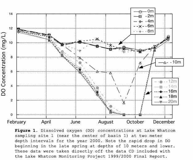
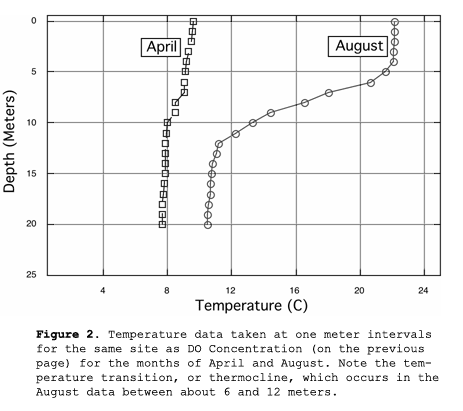
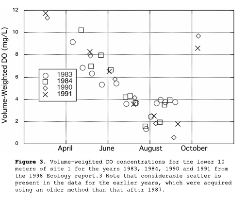
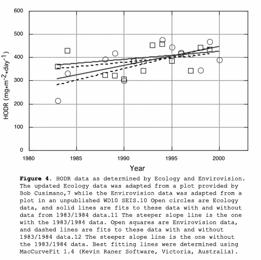